Cuyahoga Valley National Park
Trekking the CVNP
When asked where my favorite place to hike is, or where my home park is, my answer has always remained the same. The CVNP.
Set in the Cuyahoga River Valley between Cleveland and Akron, the CVNP is the only National Park in Ohio.
Millions of visitors come here each year. The parks hot spot is none other than the most gorgeous waterfall in the State of Ohio, Brandywine Falls.
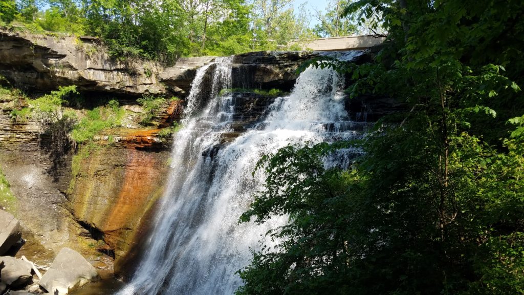
At 65 feet tall, it ranks as the third highest waterfall in Ohio. However, it is by far the most beautiful of any in Ohio. Also called “the most consistent”.
Only the nearby Twin Sisters Falls (70 feet), and (Big) Lyons Falls (80 feet) in Mohican State Park are higher. However, both emit much less water, and are not as glamourous. Not even close. Both are also drop waterfalls, not a flowing one like Brandywine.
In the CVNP, Twin Sisters Falls is difficult to get to. By way of a challenging trail, you will face muddy areas that are slippery, and you must go up a creek at points where you completely emerge your shoes. In two trips there, I’ve seen teenagers get injured both times from slipping on wet stones under the water. Both were assisted out by friends.
Speaking of injuries, Park Rangers and Safety Officials warn of climbing around and off the trail at Brandywine Falls. Again, it is mostly the curious and daring teenagers that get hurt.
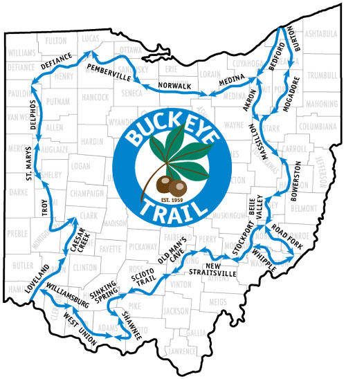
Two famed trails that pass through the CVNP are the Buckeye Trail and Ohio & Erie Towpath Trail.
The Buckeye Trail makes its way around the entire State of Ohio travelling well inside the borders. Light Blue blazes are painted on trees and markers so that you can follow the trail. The color of blue is shown in the image. The section labeled Akron is where it passes through the CVNP.
The Ohio & Erie Towpath Trail travels north to south from Cleveland down to New Philadelphia. It stretches just over 100 miles. It contains multiple surfaces, but is primarily cinder stone. It is accessible to hikers, walkers, and bicycles. Dogs are permitted via a short leash. Please cleanup after them. No horses are permitted on the trail. You can see where it passes through the CVNP in the image below.
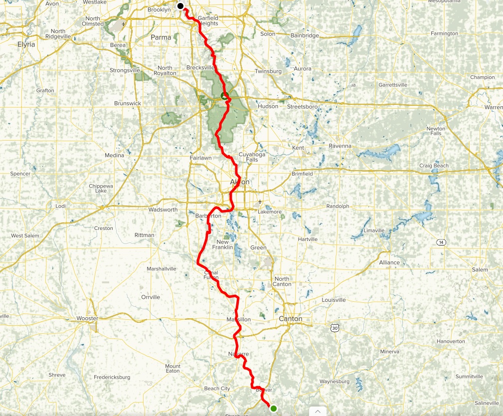
I’ve hiked many miles on both of these trails all over Ohio, but mainly in the CVNP. In fact, they sync up or connect in a few parts on trails that I hike.
The list of trail names in the CVNP are plentiful. The one trail that I most often hike is shown below. I nicknamed it due to its geographical area and length. I provided instructions for those who decide to give it a try.
Red Lock 9
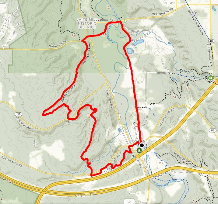
I park at the Red Lock Trailhead which is located across Highland Road from Brandywine Ski Resort and the Polar Tube Launch. You can also park at the Boston Store Visitor Center.
From the Red Lock Trailhead, you start out by crossing the road, and getting on the Towpath Trail southbound. Follow it for nearly 2.5 miles to Boston Mills Rd and turn right. (This spot is also where the Boston Store Visitor Center is. If you park here, follow the directions below.)
Follow the road over the bridge and across the intersection at Riverview Rd. Shortly after you cross through the intersection, you will see the Buckeye Trail entrance on the south side of the road.
You start out on the Buckeye Trail by going up a lengthy hill with a few switchbacks. After .8 mile, you reach an opening where a pond lies and an industrial building sits. Follow the trail along the pond, across the parking lot, and along the road. The trail then turns left back into the woods. Hiking on the road is prohibited.
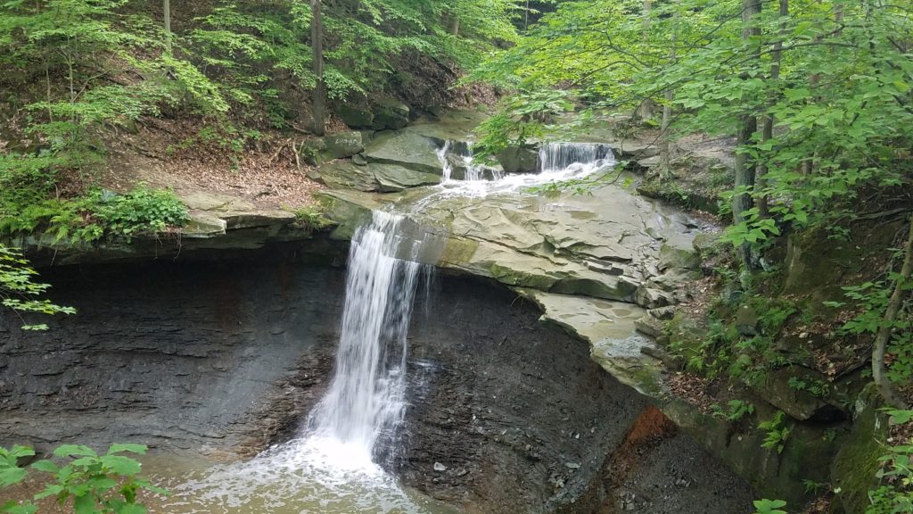
In a tenth of a mile, you will reach a parking lot. Turn right, go through the parking lot, cross the road, go up the drive, and down the hill to Blue Hen Falls. Be careful, the walk down the hill is rocky and unstable in places.
After crossing the bridge, go right, and take a left at the Y. This will continue on the Buckeye Trail and up a hill. This is also where the trail splits right towards Blue Hen Falls viewing area. I normally stop and take a short break here.
Resuming up the hill, the trail goes around a bend and guides you through 1.6 miles of forest until you cross another road.
In this next segment, you will come to an opening where power lines are. Look right and you can see Brandywine Ski Resort across the valley. Be careful, this is a high tick zone. You will go about 2 miles all together until you come to another road (Snowville Rd). Turn right, and follow the road to the intersection at Riverview Rd.
Once you cross the road, go down the stone drive to the Red Lock Trailhead connector trail. It leads you through a grassy marsh along the river. Another high tick zone.
This trail will bring you out to Vaughn Rd/Highland Rd. Turn right, and follow back to the Red Lock Trailhead where you parked.
The hike is just over 8 miles long. I call it 9 since I’ve explored Blue Hen Falls, and the Stanford House Trail which made it 9 a couple times.
At my fast pace, I have done it in under 2 hours 15 minutes. At a moderate pace, you will end up around 2:30 -2:45. At a slow and casual pace, you will be at 3-4 hours.
Bring plenty of water and some snacks like CLIF Bars and bananas or apples. This will wear you down if you aren’t used to long physical hikes.
Also, wear decent hiking shoes. Classic running shoes (simple foam), or plain old Nikes will tear your feet up. You will most likely end up with a blister or four. Don’t be the stylish genre and wear Chuck Taylors, or even flip flops like I’ve seen a few times. The look of painful discomfort on their faces said it all. Own your hike. Don’t let the hike own you.
 Previous Post
 Next Post